Preliminary assessment of sea level rise impacts to coastal ecosystems in Thua Thien - Hue
Abstract. Coastal ecosystems such as estuaries, lagoons, gulfs, mangroves, coral reefs, sea grasses support high productivity and biodiversity in Viet Nam. The coastal ecosystems play a crucial role not only in biodiversity reserve but also in socio-economic and local residents’ daily life. In the setting of increasing affection of climate change, researching impacts of sea level rise to the coastal ecosystems is necessary. This paper provide picture of coastal ecosystems and assessment of sea level rise impacts on the ecosystems in Thua Thien – Hue. In this study, climate change vulnerability is applied as methodology for the assessment. The focused factors caused by sea level rise include inundation, flood, erosion, wetland loss, and increased salt water intrusion. The analyses show that, sea level rise has different impact on communities in the coastal areas in Thua Thien Hue. Among them, seagrass communities in the lagoons seem to be more vulnerable compared to the others.
Keywords: sea level rise, coastal ecosystems, vulnerability, adaptation, lagoons
Bản toàn văn: http://tapchi.vnu.edu.vn/upload/2014/04/1314/9.pdf
Tidal regime along Vietnam coast under impacts of sea level rise
Abstract. The c-haracteristics of the tides in coastal areas are formed by the resonance between the astronomical waves transmitted f-rom the ocean into shallow water and topography in both horizontal (scale of water bodies) and vertical (depth) directions. Thus, sea level rise due to climate change that would al-ter the depth and scale of the ocean will lead to changes in tidal c-haracteristics. The ROMS model (Regional Oceanography Modeling System) was used to study the impact of sea level rise on tidal regime along the coast of Vietnam. The model was validated by using tidal current regime, and, consequently, used to simulate for the cases of global sea level rise scenarios of 0.5m, 0.75m and 1.0 m.
Keywords: Tidal regime, mean sea level, coast of Vietnam.
Bản toàn văn: http://tapchi.vnu.edu.vn/upload/2014/04/1313/8.pdf
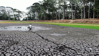
Study on Droughts in the South Central and the Central Highlands
Abstract. This paper presents research findings and drought zoning of South Central and Central Highlands. Meteorological, hydrological and agricultural drought indices were calculated for drought zoning, drought mapping and severity assessment of drought types, f-rom which recommendations were given for monitoring and remedying the effects of droughts, contributing to socioeconomic development, improving people’s lives of South Central and Central Highlands.
Keywords: Meteorological, hydrological, agricultural drought indices, drought zoning.
Bản toàn văn: http://tapchi.vnu.edu.vn/upload/2014/04/1312/7.pdf
Dimension index method for climate change vulnerability assessment
Abstract. Vulnerability assessment plays a key role on mitigation and adaptation to climate change. It can be a tool for managers and policy makers to define the area or sector which is the most sensitive to climate change in order to make appropriate policy and management decisions. Vulnerability is defined as a function of 3 components: exposure, sensitivity and adaptive capacity. As such, a method which can synchronizethe dimension of these 3 components is required to formulate the vulnerability level. This article describes a dimension index method for climate change vulnerability assessment and the result of pilot application in agriculture sector in Ca Mau province, Vietnam.
Keywords: Climate Change, DimensionIndex, Vulnerability, Assessment, CaMau.
Bản toàn văn: http://tapchi.vnu.edu.vn/upload/2014/04/1311/6.pdf
Using MODIS data for the monitoring growth and development of rice plants in Red River Delta
Abstract. At present the unusual weather phenomenas such as droughts, floods, heat, cold damage to crops more and more increase and the level of damage is more and more increase, so the risk of crop is more and more increase if they do not timely assessment, monitoring and forecasting to overcome and mitigate damage caused by them. Identifying criterias of remote sensing for the classification and assessing land cover status had become one of the popular methods in the field of remote sensing. Along with surface observation data, the integration informations of multi time remote sensing have much resolution space and time in the calculation of vegetation indices fully capable of serving the under monitor the status and monitoring the growth , development and formation of crop yield.
Keywords: Monitoring, remote sensing indicators, rice, Red River Delta.
Bản toàn văn: http://tapchi.vnu.edu.vn/upload/2014/04/1310/5.pdf
Using temporal MODIS data to detect paddy rice in Red River Delta
Abstract. Information on the area and spatial distribution of paddy rice fields is needed for food security, management of water resources, and estimation of Methan emission as well. MODIS remote sensing data including visible bands, near infrared band and short wave infrared band is foundation of calculating vegetation indices such as NDVI, EVI and LSWI. These remote sensing indices are very sensitive and strongly correlative to physiological status of plant, they are useful means for detecting and mapping paddy rice. This paper focus on an algorithm that uses time series of these vegetation indices to identify paddy rice areas based on sensivity of LSWI to the increased surface moisture during the period of flooding and rice transplanting.
Keywords: Remote Sensing, Paddy rice, NDVI, LSWI, Red River Delta.
Bản toàn văn: http://tapchi.vnu.edu.vn/upload/2014/04/1309/4.pdf
Assessing the impact of minimum temperature on crop over Winter season in northwest mountain areas of Vietnam
Abstract. This report shows the method for assessing minimum temperature effecting on probability of plant growth over the winter in the northwest mountain region of Vietnam by useing Gumbel distribution. This method determines the beginning and ending of critical temperature threholds based on ENSO scenarios. Thence, safe periods are defined for plant in the research region. The results show that: In El Nino year, safe period is longer than in La Nina year.
Keywords: Minimum temperature, Critical temperature threshold, beginning and ending date of Tn.
Bản toàn văn: http://tapchi.vnu.edu.vn/upload/2014/04/08/3.pdf
Facing multiple challenges: the future of flooding in Can Tho city
Abstract. In this paper, we present the case study of Can Tho city (the biggest city in Mekong River Delta, Vietnam), faced with multiple future challenges, namely, (i) climate change driven sea-level rise and tidal effect, (ii) increased river runoff due to climate change, (iii) increased urban runoff driven by imperviousness and (iv) enhancement of extreme rainfall due to urban growth driven micro-climatic change (urban heat islands). A set of models were used to project the future impact of the combination of these influences. Urban growth of the city was projected using the landuse simulation model (Dinamica-EGO) to predict the future landuse up to 2100. The dynamic limited-area atmospheric model (WRF) coupled with a detailed land-surface model with vegetation parameterization (Noah LSM) were used to estimate the anticipated changes in extreme rainfall patterns due to urban heat island effects.
Bản toàn văn: http://tapchi.vnu.edu.vn/upload/2014/04/1307/2.pdf
Integrated monitoring and assessment for air quality management in Hanoi, Vietnam
Abstract. In relation to air quality management (AQM), Integrated Monitoring and Assessment (IMA) is defined as a combined usage of measurements and model calculations. Integrated air quality monitoring is monitoring based on results f-rom air quality measurements f-rom fixed monitoring stations, and results obtained f-rom calculations with air quality models. IMA combines data f-rom both modeling and measurements to improve assessment of air quality. A PhD research has been conducted during 2007-2010 with the aim to evaluate air quality models developed in Denmark in the context of AQM in Vietnam with Hanoi as case study area. The Operational Street Pollution Model (OSPM) model was adapted to the traffic and vehicle emission conditions in Hanoi, and model results were compared to measurement campaigns at three streets whe-re limited measurement data were available. The OSPM model was also used for inverse modeling to estimate average vehicle emission factors based on the air quality measurement data. The OML model was used to assess the geographic distribution of air pollution in Hanoi based on an emission inventory for vehicle, domestic and industrial sources.
Bản toàn văn: http://tapchi.vnu.edu.vn/upload/2014/04/1306/1.pdf